Object Record
Images
Metadata
Object Name |
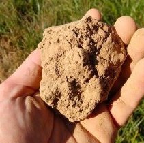
Loess |
Source |
Pottawattamie County Conservation |
Iowa History Era Tag |
First Iowans (10,000 BCE-1673) |
Catalog Number |
2018.065.001 |
Credit line |
Pottawattamie County Conservation |
Description |
Hitchcock’s rolling hills are formed from loess. The loess hills run along the eastern edge of the Missouri River flood plain. They are Iowa’s mountains, sitting 200 feet above the flat plains (in some areas). The only other place in the world that has loess hills like Iowa’s, is in China, along the Yellow River. The hills in China are nearly 300 feet thicker and older, but the loess in China has been degraded by natural and human activity. Much of the loess hills in Iowa remain mostly undisturbed, and the loess has retained its natural characteristics. The loess hills of Iowa give geologists insight into the very rare landform. It is a lightweight, loose, porous and crumbly soil. Loess soil is found in more places than China and Iowa, but in other areas, the deposits are not deep or expansive enough to be considered a landform by geologists. For any use other than instructional resources, please check with the organization that owns this item regarding copyright restrictions. |
Additional Research & Sources |
The Loess Hills were formed during the ice ages between 150,000 and 12,500 years ago. As the glaciers moved across the continent they crushed the rock beneath them into a fine powder. Water from the melting ice carried this material from underneath the glaciers and deposited it on floodplains in front of the ice sheets. The fine material was then picked up and blown away by strong winds. It was deposited on the bluff tops on the east side of the Missouri Valley where the wind lost some of its force. Loess itself is not a rarity. What makes the Iowa Loess Hills special is that it is one of the very few places where the loess is thick enough and extensive enough to create the unique landforms that we see. Because loess is very cohesive, that is it sticks together, it can form tall, nearly vertical cliffs. As a result, the water flowing through the region has sculpted the hills into the characteristic deep, steep sided gullies. The angular landscape of this region is the result of running water carving through the thick loess deposits for the past 12,000 years. - Office of the State Archeaologist. It can be used with the following standards: Standard SS.K.14 Environment: A lesson about the Loess Hills including its geography could be created. Standard SS.7.27 Iowa Role in Global Issues Today: A lesson on the preservation of the Loess Hills could be created, as well as how modern day impacts the Loess Hills. |
Notes on Related Objects |
Object is related to the following library resources, which can be found by searching the catalog number in the advanced search section: 2018.045.256: Immense Journey Book 2018.045.011: Immense Journey plus relations |
Primary/Secondary Source |
Significant - State/National |
County Tag |
Pottawattamie |
Relation |
Show Related Records... |
Multimedia Links |
Click here to view/hear the file. |
Search Terms |
Environment Environments Loess Hills Geography Rocks Hills Mountains |
Legal Status |
Ownership of this resource is held by the Pottawattamie County Conservation and has been provided here for educational purposes only, specifically for use in the Iowa Museum Association's "Teaching Iowa History" project. It may not be downloaded, reproduced or distributed in any format without written permission from the Rights Holder. For information on U.S. and International copyright laws, consult an attorney. |